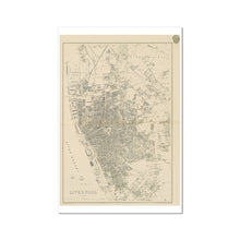
This old map of Liverpool is perhaps the only one that reproduces the whole town in such great detail, while keeping north at the top. For that reason it's one of the easiest to compare to modern maps. You can see a little more detail in the Plan of Liverpool (North Sheet), 1890 and the Plan of Liverpool (South Sheet), 1890, but the current map is older, and doesn't have the alteration of the colorued wards.
The docks line the left hand side, and the Leeds-Liverpool canal is depicted in great detail. Buildings like St George's Hall and the Borough Gaol have every corner of their outline included, giving them a realism that simpler maps lack.
The mass of buildings are also shown in enough detail to show back yards and the ins and outs of industrial buildings, like those in Everton and Kirkdale.
The cream background of this map, and the seal in the top right, lend this map an air of smartness.
Note: this map comes with white borders. This is to make it fit standard paper sizes, and allows you to get it custom-cut for framing.
See a zoomable high resolution version of the 1860: Weekly Dispatch Atlas, along with all the other old maps of Liverpool in the Historic Liverpool collection.
Print of old map of Liverpool
This is a beautiful piece of art in its own right, making it a wonderful object to hang in your home, and the high quality of the paper makes it perfect for framing.
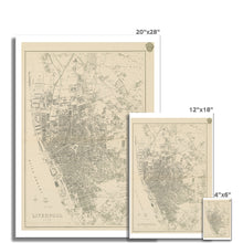
Note that this map was originally 47cm (19") x 67cm (26"). To get the full detail of this map you must buy a print of at least that size. If one is not available then please contact me for a quote on an original sized print. I can't guarantee you'll be able to read the street names if you buy a postcard-sized one! :)
Note that the images on this page don’t give a great impression of just how good this map is, because the imagery has been compressed. This is a high definition print of a large digital file.
Features:
- High resolution mapping – hugely detailed!
- Beautiful Victorian workmanship
- Printed on weighty archival paper
Whether as a gift for a loved one, or to treat yourself to something for hanging in the study, this map is a fascinating piece of history you’ll want to study again and again!


