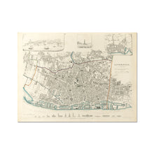
This old map of Liverpool is highly decorated, which seems to be more important to the 'Society' than absolute accuracy. You can get a feel for the layout of the Victorian town, and might even be able to navigate, but the engravings around the edge are the real pull.
The highlight is the row of buildings shown across the bottom. Many are churches, but we also have the Lyceum, Town Hall, Customs House and even the George's Dock Baths. These outlines give a great comparison of size to these buildings, many of which are long gone.
The other engravings are the View of Liverpool in the year 1650, one of the Black Rock Lighthouse off the north tip of Wirral and finally a Plan of Liverpool in the year 1729. There's much more to this map than to many of the others!
See a zoomable high resolution version of the 1849: Society for Diffusion of Useful Knowledge – James Mickleburgh, along with all the other old maps of Liverpool in the Historic Liverpool collection.
Print of old map of Liverpool
This is a beautiful piece of art in its own right, making it a wonderful object to hang in your home, and the high quality of the paper makes it perfect for framing.
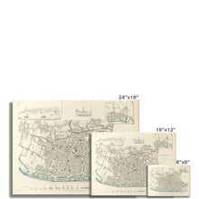
Note that this map was originally 67cm (27") x 53cm (21"). To get the full detail of this map you must buy a print of at least that size. If one is not available then please contact me for a quote on an original sized print. I can't guarantee you'll be able to read the street names if you buy a postcard-sized one! :)
Note that the images on this page don’t give a great impression of just how good this map is, because the imagery has been compressed. This is a high definition print of a large digital file.
Features:
- High resolution mapping – hugely detailed!
- Beautiful Victorian workmanship
- Printed on weighty archival paper
Whether as a gift for a loved one, or to treat yourself to something for hanging in the study, this map is a fascinating piece of history you’ll want to study again and again!


