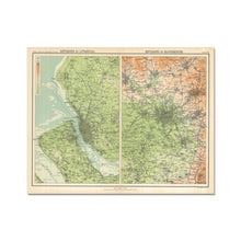
If you really want to see Victorian Liverpool in its wider context, then this map is the one for you. Here, Liverpool is paired with its rival, Manchester, in a map which contrasts their two topographic settings.
Manchester, as shown by the orange colouring, is surrounded on the north and east by the Pennines. Liverpool has the River Mersey flowing alonside it, and the land is much flatter.
The level of detail here is very much an overview. It's interesting, however, to see the three large parks (Sefton, Newsham and Stanley) in their early days sitting on the outskirts. Even today these parks provide oases from the built-up city.
The map also shows the tide levels, and to the north of Liverpool we can see the much less built-up towns of Sefton.
See a zoomable high resolution version of the 1898: Environs of Liverpool – Royal Atlas of England and Wales, along with all the other old maps of Liverpool in the Historic Liverpool collection.
Print of old map of Liverpool
This is a beautiful piece of art in its own right, making it a wonderful object to hang in your home, and the high quality of the paper makes it perfect for framing.
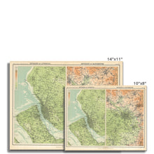
Note that this map was originally 83cm (46") x 55cm (36"). To get the full detail of this map you must buy a print of at least that size. If one is not available then please contact me for a quote on an original sized print. I can't guarantee you'll be able to read the street names if you buy a postcard-sized one! :)
Note that the images on this page don’t give a great impression of just how good this map is, because the imagery has been compressed. This is a high definition print of a large digital file.
Features:
- High resolution mapping – hugely detailed!
- Beautiful Victorian workmanship
- Printed on weighty archival paper
Whether as a gift for a loved one, or to treat yourself to something for hanging in the study, this map is a fascinating piece of history you’ll want to study again and again!


