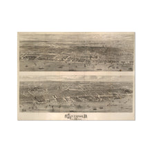
This old map of Liverpool was originally given away with a supplement to the newspaper Illustrated London News! It's an incredibly detailed engraving of Liverpool in two halves.
The style lies somewhere between the stylistic Ackermann's Panorama and the subtle brushstrokes of Isaac's bird's eye view from 1859. The docks are busy with ships moving in and out, and the river teems with commerce. The quaysides themselves are stacked with goods, from timber to cotton bundles, and dockworkers wander back and forth.
It's an image of Liverpool in action, with smoke coming from chimneys across the city and mills turning in the wind right up into the hills. Traffic throngs the Strand, with horse-drawn carts and steam locomotives sharing the thoroughfare.
Parts of central Liverpool are depicted at a time since when they've changed immeasurably. Lime Street station has its original frontage, before the North Western hotel was built. St John's church stands in grounds behind St George's Hall, and the Museum of Liverpool (now the World Museum) is shown with its plinth, before the steps were installed.
See a zoomable high resolution version of the 1865: Illustrated London News View of Liverpool from the Mersey, along with all the other old maps of Liverpool in the Historic Liverpool collection.
Print of old map of Liverpool
This is a beautiful piece of art in its own right, making it a wonderful object to hang in your home, and the high quality of the paper makes it perfect for framing.
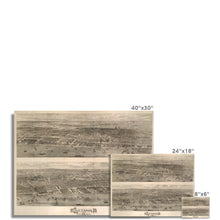
Note that this map was originally 160cm (63") x 121cm (48"). To get the full detail of this map you must buy a print of at least that size. If one is not available then please contact me for a quote on an original sized print. I can't guarantee you'll be able to read the street names if you buy a postcard-sized one! :)
Note that the images on this page don’t give a great impression of just how good this map is, because the imagery has been compressed. This is a high definition print of a large digital file.
Features:
- High resolution mapping – hugely detailed!
- Beautiful Victorian workmanship
- Printed on weighty archival paper
Whether as a gift for a loved one, or to treat yourself to something for hanging in the study, this map is a fascinating piece of history you’ll want to study again and again!


